Angangueo Storm – Putting it into Perspective
Thursday, February 18th, 2010 at 4:33 pm by Chip TaylorFiled under Mexico | Comments Off on Angangueo Storm – Putting it into Perspective
It seems to be part of the human condition to assign blame whenever things go horribly wrong. Had this or that not been done, the destruction in Mexico might not have been as bad, but it would have been a disaster just the same.
Human abilities to predict the future are generally based on past experiences. The problem is that we don’t remember the past very well nor do we learn from the experiences of others – traits that certainly contribute to the devastation that results from extreme events. Even if we know how to do the right thing, we are often constrained by economics, so try to convince ourselves that “the worst” will not happen, at least not in our lifetime. This sounds like our collective behavior with respect to climate change doesn’t it? But, even planning ahead doesn’t always work. In the United States, the Corps of Engineers plans projects in anticipation of 100-year floods that subsequently seem to occur at 20-30 year intervals! And let’s not forget Katrina – we were told years in advance that the levies designed to protect New Orleans from surges due to hurricanes were insufficient, but nothing was done.
This said, it is hard to plan for the future and even harder to plan for an event that has never occurred before – like extreme rainfall in the dry season. Angangueo and the surrounding communities were certainly not prepared for the amount of precipitation that occurred from 31 January through 4 February. How much rain was there? We may never know. About 15 inches (381mm)* of rain was recorded in Zitácuaro by Pablo Span at Rancho Cayetano, some 16 miles (26km) to the south of Angangueo, and similar amounts probably occurred in the Angangueo drainage.
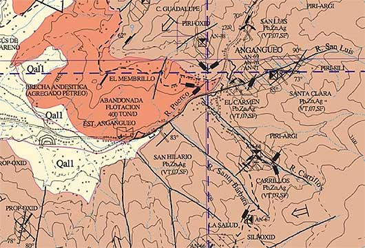
The drainage in which Angangueo and the upslope communities of Dolores and Catingon lie is most unusual**. Dwellings and businesses crowd the narrow valley floor for about 3 miles over a fall in elevation of 1000 ft or more. Many houses are backed up to a small stream, Rio Puerco, that drains through the valley, and housing festoons the steep, mostly deforested, slopes on either side of Angangueo. It is a pattern of living that has lasted for a very long time, as the town itself is hundreds of years old. Much of the town is now lost since the culverts designed to handle normal, even heavy, rainfall couldn’t handle the deluge – nor could the rain-soaked slopes withstand the burden of saturated soils, slipping here and there burying residents in their homes.
The devastation to the town’s infrastructure, the loss of homes and businesses, the landslides, and the groaning and rumblings of some hillsides that threatened additional landslides, led to the evacuation of most, if not all, of the inhabitants of this picturesque mining town on 10 February. There have been numerous reports in the Mexican press about relocating all of the residents of Angangueo, but this won’t happen. The town will come back and when it does, let us hope for the sake of the residents and the future of the town that lessons have been learned. Hopefully, the drainage will be reengineered and sensible restrictions applied as to where people live. Reforesting the valley’s slopes should be a priority as well to reduce runoff and the chance of future landslides.
*For Michoacán, the average precipitation for January and February combined was 17.9mm for the period 1941-2005. July received the most precipitation, 185.4mm. So, 15 inches, or 381mm, of precipitation (if that was indeed the amount that fell between 31 January and 4 February) was more than double the average rainfall for the wettest month.
**The rivers of Angangueo. This map shows the rivers or drainages that converge on Angangueo. Rio Puerco drains the valley NE of Angangueo running parallel to the road from Sierra Chincua continuing down slope through the town. This stream is joined by four other rivers coming from the east; Rio El Charco, Rio San Luis, Rio Carrillo, and Rio Santa Barbara.


Sorry, comments for this entry are closed at this time.