Driving Through Mexico After the Storms
Saturday, February 20th, 2010 at 9:06 pm by JimFiled under Mexico | Comments Off on Driving Through Mexico After the Storms
The account below describes a trip taken on 19 February 2010 from Tlalpujahua to Chincua, El Rosario, and Cerro Pelon by Paul and Phill Justice of Rocamar Tours. This is the most comprehensive report we have seen of the conditions in the monarch overwintering area.
Paul and Phill have also posted lots of photos via Flickr.
by Paul and Phill Justice, Rocamar Tours, 19 February 2010
Tlalpujahua to Chincua: the road is clear, there are some minor mud slides and trees across the road, but they have been cleared and cut.
Sierra Chincua: we arrived around 11:00 and it was 40 degrees. There were snow patches in and around the parking lot. We were told that last night it snowed about 4 inches, but that most of it was washed away with rain that followed. There were a moderate number of national tourists there (one bus, one van and a couple of cars). We did not take the time to go in to the butterflies as we knew we had a lot of ground to cover. The road in to the sanctuary is better than we have ever seen it in nine years. Good reliable contacts there told us that the butterflies about 25 minutes down the trail. They are on the trail across the field and not the one up the mountain behind the washrooms. We are told that the majority of the butterflies are hibernating in the trees and there are very few actually in flight.
Chincua to North end of Angangueo: The first 5 minutes leaving Chincua and exactly as they have always been. Further down the road there are two major wash-outs where the road is reduced to one lane. There are also various fairly major mud slides that have all been cleared to allow at least one lane of traffic to pass.
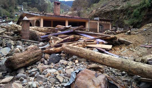
Angangueo: The North end of Angangueo where all the furniture manufacturing shops and homes along the river were is fairly heavily damaged, but we were still able to drive on the road. A number of homes were washed completely into the river along with cars and personal belongings. The area before you reach the split in the road to downtown is devastated. Some houses have as much as 6 feet of mud and rubble inside. There is no road left in this area because it is covered in anywhere from three and six feet of mud and stones. The vehicles along the roadside look like they have been in horrific accidents as large stones and boulders have smashed into them and in some cases ripped the roofs right off of them. We saw a Jetta hanging from a second storey balcony.
In this area the army has brought in heavy equipment including loaders, shovels, graders and bulldozers. The army in particular seemed to have a really good handle on the task at hand. We saw that many residents had returned to dig out their homes using hand shovels and flimsy wheelbarrows. There were many residents in the entire town and it is by no means a ghost town nor does it look like it will become one. There was a steady stream of people up and down the road. State and federal governments are giving out mattresses, hot food and medical care. We saw municipal police with pickups full of free clothing that they were distributing. We also saw a number of emergency vehicles from other municipalities (Uruapan in particular) helping out. There were officials from SEMARNAP, SECTUR, and just about every state and federal group imaginable milling around the streets. Clearly this is getting a lot of exposure from groups that can contribute. A number of cars had announcements on them written in wax crayon with things like “Angangueo, we will pull through” and “Angangueo will not die”, etc. It would take many paragraphs to describe how bad the devastation is in this particular section of road before the split. In other cases homes only 10 or 15 feet from the river were not affected at all. There is one section in particular where the entire side of the mountain washed out right down to bare rock from the top down, a kilometer or more long.
Angangueo bypass to Ocampo: Although much of the new concrete bypass road has caved in and a number of homes with it, beyond the split the road is very accessible. After the right hand turn to Zitacuaro, the balance of the town has very little damage but there has obviously been a considerable amount of water that came through. The road to Ocampo and Ocampo itself show no real evidence of damage.
El Rosario: The road to El Rosario had a few minor mud slides that are almost finished being cleaned up. There is only one washout just before the parking lot for the sanctuary, but it has been temporarily repaired. Just before the turn off for the parking lot there is massive erosion around what is usually a small creek bed. It would measure about 100 feet across. We saw the remains of one concrete house in the middle of this that was completely demolished, but any timber homes in this path would have been washed away for sure. Our guide at the sanctuary confirmed that everything along this creek was washed away, but could not confirm the number of people killed. Upon arrival to the actual sanctuary we were amazed to find only a handful of tourists – a group of maybe 7 from France and a few federal government workers who had come to take a look. The butterflies were only about 100 meters from the new pavilion. They were all hanging in the trees and only maybe a dozen or so in the air when we arrived. The forest floor had about a 50% ground cover of dead butterflies. The butterflies were only in about 20 trees*. The sun finally came out around 1:30 and the temperature rose to about 70 degrees – a number of monarchs took flight, but there simply weren’t the numbers to really appreciate them. There were virtually no concession stands open and our guide informed us that they have not had much traffic at all.
*(From an additional communication: “A guide and friend of ours tells us that the colonies at Rosario have indeed split into smaller colonies around the mountain”.)
Rosario to Zitacuaro: The same ride as always.
Macheros: The road to the sanctuary has very little damage – a fallen tree or two that have been cleared. It was about 70 degrees at the village and we met our very reliable contact there who said that the butterflies are as spectacular as ever. He told us that over November and December they had almost no tourists, but that they are getting more tourism than they have ever had as a result of the inaccessibility and poor showings at other sanctuaries. Some of the guides that would usually use other sanctuaries have been bringing them to Macheros. The village has a number of new concrete roads and a new community building built in the last year. This town is a great example of what a tremendous impact tourism income from the monarch butterfly phenomenon can have.


Sorry, comments for this entry are closed at this time.